Flying thermal camera images cow pats
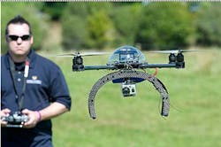
Researchers atMassey University’s (Palmerston, New Zealand) Centre for Precision Agriculture have been testing a remote-controlled hexacopter that can fly above farmland in an effort to help farmers map their pastures and increase efficiency.
The carbon fiber hexacopter made by the Australian company Aerobot has been fitted with cameras that can take time-lapse photographs during flights as well as video footage and infrared images.
Centre director Professor Ian Yule says the hexacopter has been used on a number of agricultural projects so far. In one, it was used to gather infrared photos that allowed the researchers to determine the location of cow pats and their proximity and distribution to a drainage collector on a farm. In another, it was used to map the quality of maize.
Those interested in performing similar research canpurchase a hexacopter here.
-- by Dave Wilson, Senior Editor,Vision Systems Design