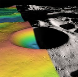
LOLA finds ice in lunar crater
Data from the Lunar Orbiter Laser Altimeter (LOLA) on board NASA's Lunar Reconnaissance Orbiter (LRO) spacecraft indicates that ice may make up as much as 22 per cent of the surface material in a crater located on the south pole of the moon.
Using the laser altimeter, a team of NASA and university scientists examined the floor of the Shackleton crater, which is named after the Antarctic explorer Ernest Shackleton. They found the crater's floor is brighter than those of other nearby craters, which is consistent with the presence of small amounts of ice.
In addition to the possible evidence of ice, the group's map of the Shackleton revealed a remarkably preserved crater that has remained relatively unscathed since its formation more than three billion years ago. The crater's floor is pocked with several small craters, which may have formed as part of the collision that created it.
The LOLA instrument itself pulses a single laser through a Diffractive Optical Element (DOE) to produce five beams that illuminate the lunar surface. For each beam, LOLA measures time of flight, surface roughness and surface reflectance.
The image above shows the elevation (left) and shaded relief (right) image of the 21-km-diameter Shackleton crater. The structure of the crater's interior was revealed by a digital elevation model constructed from over 5 million elevation measurements from the LOLA instrument.
Interested in reading more about space imaging technologies? Here’s a compendium of five of the top stories on the subject that Vision Systems Design has published over the past year.
1. Researchers map Jupiter's moon
A group of scientists led by Dr. David Williams of Arizona State University (Phoenix, AZ) has produced the first global geologic map of Io, the innermost large moon of Jupiter.
2. Imaging algorithms map out the moon
Computer scientists at NASA's Ames Research Center (Moffett Field, CA, USA) have used image processing algorithms to transform legacy data from the Apollo Metric Camera onboard the Apollo 15, 16 and 17 spacecraft into an immersive 3-D mosaic map of a part of the moon.
3. Moon mapping produces high-resolution models on 100-m scale
The highest resolution near-global topographic map of the Moon ever created has been released by the Arizona State University (Phoenix, AZ, USA) team that oversees the imaging system on board NASA’s Lunar Reconnaissance Orbiter (LRO).
4. Titanium treasure trove found on the Moon
A team from the School of Earth and Space Exploration at Arizona State University (Tempe, AZ, USA) has created a map of the Moon that shows areas rich in titanium ores.
5. Wide-angle camera captures sharper images of moon landing sites
A camera onboard NASA's Lunar Reconnaissance Orbiter (LRO) has captured the sharpest images ever taken from space of the Apollo 12, 14, and 17 landing sites on the moon.
-- Dave Wilson, Senior Editor, Vision Systems Design
