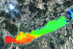
Scientists awarded grant to develop lake surveillance system
A consortium of scientists from six UK universities and research institutes has been awarded a £2.5m grant to create the world's first satellite-based global lake surveillance system, to monitor how lakes and reservoirs are being affected by environmental change.
Funded by the Natural Environment Research Council (NERC), the consortium project, entitled Globolakes, will be led by Dr. Andrew Tyler, Head of Biological and Environmental Sciences at the University of Stirling (Stirling, Scotland, UK).
Previous research has already shown how the ecology of lakes can be damaged by external changes such as the influx of certain nutrients, increased sediment load and climate change. Frequently the changes lead to algal blooms that can deplete oxygen concentrations and produce toxins that are harmful to human health.
Yet despite their importance and sensitivity to change, only a very small number of lakes have been studied consistently and in any detail.
According to Dr. Tyler, the grant will enable the researchers to observe the conditions of over 1000 lakes around the globe, allowing them to gain a deeper insight into their responses to environmental change and develop an early warning system to detect the onset of harmful algal blooms.
Stirling University will be heading the consortium, which includes the universities of Dundee, Edinburgh and Glasgow, the NERC Centre for Ecology and Hydrology and the Plymouth Marine Laboratory.
GloboLakes builds on the forthcoming launch of next generation satellites by the European Space Agency's program Global Monitoring for Environment and Security. Satellites due to be launched during the course of the project, called Sentinel 2 and 3, will provide the images of the lakes.
Related articles from Vision Systems Design that you might also find of interest.
1.Satellite imager captures perfect picture of a blue Moon
The Spinning Enhanced Visible and Infrared Imager (SEVIRI) instrument aboard the third Meteosat Second Generation (MSG-3) satellite has captured a perfect picture of a " blue" Moon.
2. Scientists spy penguins via satellite
An international team of scientists has used satellite images to estimate the number of penguins at each colony around the coastline of Antarctica in order to produce more accurate population studies.
3.Night-time lights indicate disease hot spots
Princeton University (Princeton, NJ, USA) researchers say that satellite images of night-time lights can provide a new way of pinpointing disease hotspots in developing nations.
-- Dave Wilson, Senior Editor,Vision Systems Design
