Unmanned aircraft to capture hyperspectral images
Engineers working on the TerraLuma Project at the University of Tasmania, Australia are bringing hyperspectral capabilities to their fleet of unmanned aircraft systems (UAS).
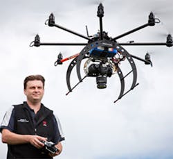
To do so, they will be employing Headwall Photonics' (Fitchburg, MA, USA) Micro-Hyperspec sensor on-board a multi-rotor SkyJib airframe from Droidworx (Waikato, New Zealand). SkyJib is a purpose-built aerial platform, which the TerraLuma team has adapted to carry scientific instruments.
One of the unique aspects of the TerraLuma project is that the university researchers use multiple sensors -- visible, multispectral and hyperspectral (VNIR), thermal, and LiDAR -- to map and monitor different aspects of the environment.
They have worked on a range of applications such as mapping and monitoring vegetation in remote locations, deriving 3-D tree structure for forest inventories and landslide mapping. More information on the project can be found here.
Related articles on UAVs from Vision Systems Design.
1. Cameras capture bird motion to aid with development of UAV
Researchers at the Office of Naval Research (ONR; Arlington, VA, USA) are studying the flight of birds in the hope of using what they learn to help with the development of small unmanned aerial vehicles.
2. UAV captures 3-D images of buildings
Unmanned aerial vehicles (UAVs) equipped with all manner of cameras are now being put to use in a variety of applications for monitoring vegetation, assessing power grid damage and helping soldiers to spot suspicious activity.
3. UAVs help utilities bring back the power
Researchers at New Mexico State University (NMSU; Las Cruces, NM, USA) and the Electric Power Research Institute (EPRI; Palo Alto, CA, USA) recently completed tests that concluded that unmanned aircraft can be safely and effectively used to assess power grid damage following a storm or natural disaster.
4. Robot vision helps guide UAV for crop spraying
Australian researchers are developing a flying robot as small as a dinner plate and a fleet of eco-friendly robotic farmhands that could help cut down the amount of herbicide sprayed on crops.
5. Small UAV uses hyperspectral imager
Headwall Photonics' (Fitchburg, MA, USA) Micro-Hyperspec imaging sensor is being successfully deployed onboard small commercial unmanned aerial vehicles (UAVs) to help agriculturalists monitor vegetation over wide areas.
-- Dave Wilson, Senior Editor, Vision Systems Design