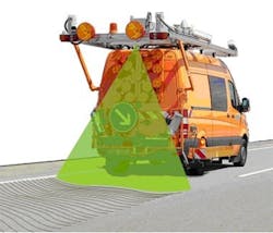
Scanner measures evenness of roads
A team at theFraunhofer Institute for Physical Measurement Techniques IPM (Freiburg, Germany) has developed the first laser scanner to be approved by the Federal Highway Research Institute for measuring the evenness of roads.
The shoe-box sized scanner, which is mounted on vehicle at a height of three meters, can scan any road up to four meters wide. To do so, an octagonal mirror rotating inside the scanner steers the laser beam across the road perpendicular to the direction the vehicle is travelling in.
The light from the laser is reflected from the asphalt back to the scanner, where it is detected by a sensor. The distance between the scanner and the surface of the road can be inferred from how long it takes the laser light to travel back, and measurements are accurate to between 0.15 and 0.3 millimeters.
The orientation and position of the vehicle is accomplished using a Global Navigation Satellite System (GNSS) and an inertial measurement system. IPM's so-called Pavement Profile Scanner (PPS) has already passed initial field tests.In co-operation with road surveyors from Lehmann + Partner, the IPM researchers have used it to scan a total of 15,000 kilometers of highway and other major roads across Germany since last summer.
Further details can be found here.
Related items from Vision Systems Design that you might also find of interest.
1.Vision systems examine cracks in pavement
A technical paper written by Richard Wix and Roland Leschinski from the ARRB Group (Melbourne, Victoria, Australia) assesses the pros and cons of four different systems currently used to measure cracking in pavements.
2.3-D Scanner images dental molds
Combining structured lighting, smart optics, and software, a 3-D scanner provides dental technicians with a faster way to image dental molds.
3.Laser scanner enables 3-D modeling of key impellor at hydroelectric plant
Facing an extended shutdown due to a faulty impellor, a major hydroelectric facility ooked for assistance in creating a 3-D model for a replacement part.
4.3-D scanner scopes out ship's engine room
Global maritime and offshore oil and gas engineering company Harris Pye (Barry, South Wales, UK) has used a 360 degree 3-D scanner to survey the engine room of a liquefied natural gas (LNG) carrying vessel to ascertain the best system for a ballast water treatment installation.
-- Dave Wilson, Senior Editor,Vision Systems Design
