UAVs image volcano
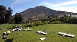
A team of NASA researchers has deployed three UAVs equipped with video cameras into and above the sulfur dioxide plume of Costa Rica's active Turrialba volcano near San Jose.
Led by David Pieri of NASA's Jet Propulsion Laboratory (Pasadena, CA, USA), the team launched 10 flights of the remote controlled UAVs into the volcanic plume and above the rim of Turrialba's 10,500ft summit crater between March 11 and 14.
The small, twin electric engine Dragon Eye UAVs were operated by researchers at NASA's Ames Research Center (Moffett Field, CA, USA). Weighing less than six pounds each and with a wingspan of 3.75ft, they have visible and infrared video cameras and can carry a one-pound instrument payload for up to an hour within a volcanic plume.
The researchers also equipped them with sulfur dioxide sensors, particle sensors and automatic atmospheric sampling bottles keyed to measure sulfur dioxide concentration.
During the flights, the team co-ordinated its data gathering with NASA's Advanced Spaceborne Thermal Emission and Reflection Radiometer (ASTER) instrument on NASA's Terra spacecraft, allowing scientists to compare sulfur dioxide concentration measurements from the satellite with measurements taken from within the plume.
Scientists believe computer models derived from the study will contribute to safeguarding the National and International Airspace System, and will also improve global climate predictions and mitigate environmental hazards (such as sulfur dioxide volcanic smog) for people who live near volcanoes.
More information on the project can be found here.
Related items from Vision Systems Design that you might also find of interest.
1. UAVs help utilities bring back the power
Researchers at New Mexico State University (NMSU; Las Cruces, NM, USA) and the Electric Power Research Institute (EPRI; Palo Alto, CA, USA) recently completed tests that concluded that unmanned aircraft can be safely and effectively used to assess power grid damage following a storm or natural disaster.
2. Cameras capture bird motion to aid with development of UAV
Researchers at the Office of Naval Research (ONR; Arlington, VA, USA) are studying the flight of birds in the hope of using what they learn to help with the development of small unmanned aerial vehicles.
3. UAV captures 3-D images of buildings
Unmanned aerial vehicles (UAVs) equipped with all manner of cameras are now being put to use in a variety of applications for monitoring vegetation, assessing power grid damage and helping soldiers to spot suspicious activity.
-- Dave Wilson, Senior Editor, Vision Systems Design