UAVs guide students around MIT campus
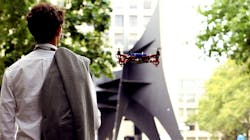
MIT’s SENSEable City Lab has developed an unmanned autonomous vehicle (UAV) system which uses GPS and cameras to guide students and visitors around the MIT campus.
The system, called Skycall, allows its users to summon it via phone call and then flies to their location to guide them on to their destination. Skycall’s prototype system consists of a drone quadcopter equipped with onboard autopilot, camera, Wi-Fi, GPS navigation, and sensors that allow it to fly autonomously to specific locations, according to Gizmag.
Not only does the Skycall copter have an onboard camera that provides information to the ‘base’ location upon encountering a user, but it also has a manually-controlled camera which is accessible to users via the Skycall app.
Skycall’s app was developed for human/UAV interface, which enables users to make requests and for the UAV to both locate and wirelessly communicate with them. When a user is in range—which the team says could reach a few miles—and presses the ‘call’ button, SkyCal instantly accesses the users GPS location via phone and relays the coordinates to the nearest available UAV.
When a Skycall UAV arrives, users are able to communicate via the app and the onboard WiFi. This includes pausing it and getting it to hover in place, and indicating when to resume its movement when needed. The UAV will also detect if a user is falling behind and ask them to close the distance. In addition, the UAV will act as a personal tour guide, offering descriptions of different landmarks along the way.
SkyCall, according to the MIT SENSEable City Lab, is in Phase I of a larger development program which is currently underway with the broader aim of exploring novel, positive uses of UAV technology in the urban context.
View more information on the Skycall project.
Also check out:
U.S. Coast Guard makes first drug bust using UAVs
UAVs to survey mangrove jungles for mosquito detection
Robots, UAVs used to photograph lions in the wild
Share your vision-related news by contacting James Carroll, Senior Web Editor, Vision Systems Design
To receive news like this in your inbox, click here.
Join our LinkedIn group | Like us on Facebook | Follow us on Twitter | Check us out on Google +
About the Author

James Carroll
Former VSD Editor James Carroll joined the team 2013. Carroll covered machine vision and imaging from numerous angles, including application stories, industry news, market updates, and new products. In addition to writing and editing articles, Carroll managed the Innovators Awards program and webcasts.