Security and Defense: UAVs integrate vision and global positioning
Following a contract awarded by the Office of Naval Research (Arlington, VA, USA; www.onr.navy.mil) and the NAVSEA Advanced Visualization Office (Washington Navy Yard, DC, USA; www.navsea.navy.mil), Imperx (Boca Raton, FL, USA; www.imperx.com) has developed a prototype unmanned aerial vehicle (UAV) that integrates vision, global positioning, and infrared (IR) technology. Designed to operate within the payload compartment of a UAV from Aerosonde (Notting Hill, Australia; www.aerosonde.com), the system incorporates an off-the-shelf camera, data transceiver, GPS system, and a custom frame grabber and CPU. To capture images from the aircraft, Imperx chose the company’s IPX-4M15C, a 2048 × 2048-pixel Camera Link-compatible color camera that features 8- or 10-bit digital output, and programmable frame rate and integration time.
“In the design of the UAV,” says Petko Dinev, CEO of Imperx, “this camera was modified with a dc-powered auto-iris function to regulate the amount of light entering the camera in different lighting conditions.” After images are captured they are transferred via the Camera Link interface to Imperx’s FrameLink-JFLEX frame grabber that is integrated with a JRex-PM CPU board from Kontron (San Diego, CA, USA; www.kontron.com) via a proprietary PC-104-like interface. Kontron’s 3.5-in. CPU board is equipped with a 1.6-GHz Pentium M processor and uses Intel’s 855GM chipset and a 400-MHz front-side bus and supports up to 1 Gbyte of DDR-RAM. Both Imperx and Kontron will offer the frame grabber/CPU combination as a separate product for other applications such as quality assurance, production automation, materials flow, and machine control.
According to Dinev, PC-104 frame grabbers and CPUs were considered in the design of the system. “However,” says Dinev, “available PC-104 CPUs were not powerful enough to handle the MJPEG compression required by the system.” In operation, captured images are first buffered by the frame grabber memory and transferred to the host PC.
“Because of the large amount of data associated with these images,” says Dinev, “they must first be compressed using a standard MJPEG algorithm. After compression, a GPS header file must be appended to the images before data can be transmitted to a ground station. Imperx developed its own MJPEG compression algorithm, which is performed on the host CPU. By integrating the Kontron JRex-PM CPU with an L-Band transceiver with GPS from NAL Research Corporation (Manassas, VA, USA; www.nalresearch.com), serial commands could be used to interrogate the GPS that, in turn, supplies global-positioning data from the Iridium satellite communications system to the host computer. This information is then integrated as a header file into each image.
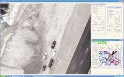
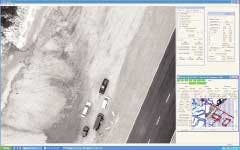
To transmit image and position data to a ground monitoring station, the system uses a wireless RF data transceiver that is interfaced to the host computer via TCP/IP. After transmission, the ground station uses a similar RF data transceiver to capture the images and GPS information of the aircraft. Software running on the PC-based ground station then provides a real-time display of the received images and includes overlay maps, camera control functions, and the position and pitch and roll of the aircraft. It also provides a remote camera control that allows the ground station operator to configure the camera’s operating parameters in real time.
“In many applications,” says Dinev, “it’s necessary to equip the aircraft with infrared capability.” Because of this, the company has also demonstrated a system that uses the MicroCamera, a Camera Link-compatible camera from Sensors Unlimited (Princeton, NJ, USA; www.sensorsinc.com) that can capture 320 × 256 pixels in the short-wavelength IR spectrum.
Currently, the system is undergoing field trials at NAVSEA Carderock. It is scheduled for deployment in Iraq, where it will be used to search for roadside munitions along convoy routes of coalition troops.
