Technology Trends: Linux-powered lidar studies global climate changes

Studying phytoplankton is providing researcher's at NASA Goddard Space Flight Center (Wallops Island, VA) Observational Science Branch a better understanding of global climate change. To study phytoplankton, NASA engineers have built an airborne oceanographic light detection and ranging lidar (AOL), a laser spectrofluorometer that measures a variety of reflected and induced optical properties, from which a number of oceanographic water properties can be derived.
Using a dual-wavelength laser and multichannel fluorospectrometer, two laser wavelengths, one UV (355 nm) and one green (532 nm), are transmitted the ocean surface from an aircraft. These frequencies interact with water molecules, causing a Raman shift in the laser frequency. If biological organisms containing chlorophyll and/or phycoerythrin are present in the water, 532-nm laser light is absorbed and re-emitted as bands of fluorescence. The 355-nm radiation causes fluorescence of dissolved organic material in the water.
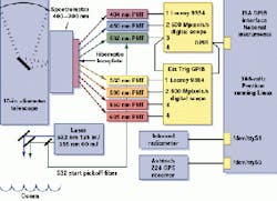
RIGHT. Running Linux, scientists at the NASA Goddard Space Flight Center Observational Science Branch have developed a lidar system using off-the-shelf photomultipliers, computers, and graphical-user-interface software. In operation, data from the photomultipliers are digitized by digital oscilloscopes and transferred to a PC running Linux. The system incorporates a global positioning system and an infrared radiometer to track and study captured data.
Based around a rack-mounted 166-MHz Pentium PC, the system uses eight H6779/H6780/H5784 series photomultiplier modules from Hamamatsu (Bridgewater, NJ) to convert optical pulses obtained into electrical pulses. To capture and digitize the laser-induced fluorescent signals from the photomultipliers, two 9354 oscilloscopes from Lecroy (Chesnut Ridge, NY) digitize data at 500-Mpixels/s, providing a digital sample every 2 ns on each of four channels.
While the first scope is configured to capture 404-, 450-, and 532-nm return signals, the second captures 560-, 590-, 650-, and 685-nm return signals. The 404- and 450-nm signals are the result of stimulation of the ocean by the 355-nm laser pulse. The remaining signals result from the stimulation of the ocean by the 532-nm laser pulse.
To interface the digital oscilloscopes to the PC, the AT-GPIB/TNT card ISA-based GPIB interface board from National Instruments (Austin, TX) is used. Using a Linux GPIB driver written by Claus Schroeter at the University of Berlin (Berlin, Germany; clausi@chemie. fu-berlin.de), this board provides data to the PC for further processing.
To correlate this data with the AOL on-board infrared temperature sensor and an Ashtech Z-12 12-channel global positioning system from Magellan (Santa Clara, CA), NASA engineers developed an operator interface programmed in Tcl7.6/Tk4.2 from Scriptics (Mountain View, CA). This provides developers with a graphic user interface to control both oscilloscopes and view plotted incoming lidar data.