By Andrew Wilson,Editor
Human casualties and aftereffects of illegal gunfire have recently plagued schools, businesses, and government agencies, among others, throughout the United States. To combat illegal gun use, the Los Angeles County Sheriff's Department (LASD) in California has implemented a gunshot-location imaging system. Developed by Trilon Technologies LLC (Los Altos, CA), the digital audio/mapping system detects gunfire noise and provides imaging locality information that helps police or law-enforcement officers respond rapidly, safely, and effectively to shooting incidents.
Dubbed ShotSpotter, the system is based on work performed by John Lahr of the United States Geological Survey (Menlo Park, CA). The original system developed by Lahr measured the different times of arrival of a seismic wave at several locations and was used to pinpoint the exact source of earthquakes.
In the design of the ShotSpotter system, several acoustic sensors are positioned throughout a specific area and are networked over standard telephone lines to a police dispatch center. Within a few seconds after gunfire, the location of the site is calculated by triangulation methods and displayed on a computer map of the community. Dispatchers listen to the audio data, determine whether the noise is actually gunfire, and then direct officers to the gunfire location. At a later time, police officials can retrieve this information to investigate and analyze selected incidents.
Digitized audio
The ShotSpotter system is composed of a network of acoustic sensors distributed across a square-mile area in which illegal gunfire has been active or suspected (see Fig. 1). To capture the audio data, eight electric microphones are mounted in weatherproof enclosures installed on various buildings. "Although the microphones are not sensitive enough to monitor street conversations," says Jason Dunham, Trilon's manager of software engineering, who developed the audio system, "they can detect gunfire from a mile or more away."
Dunham connected standard telephone central-office-exchange services to deploy the sensors with minimal infrastructure investment. After the acoustic signals are received at the police center, they are digitized by a PCI MIO-16-E4 PCI-based data-acquisition board from National Instruments (Austin, TX). "By processing up to 16 analog inputs with 12-bit resolution at 250 ksample/s," says Dunham, "the board proved more than adequate in digitizing eight audio-signal sources."
Using National Instruments LabVIEW software, Dunham designed a data-acquisition system capable of operating 24 hours/day, responding to triggers on any channel, and constantly monitoring background noise. "When any channel crosses a threshold level," he says, "the triggering system responds and checks the event for the characteristics of a gunshot sound, such as a short risetime. Potential gunshots from each channel are fed into a routine that identifies potential gunshot events that are communicated to police dispatch personnel."
Urban and suburban environments contain many different sounds that resemble gunshots. Gunshot sounds can also have different characteristics depending on local vegetation, structures in the immediate area, and sound paths to the sensors. Consequently, careful attention was paid when developing the audio-analysis algorithms. "The user interface of LabVIEW also helped us install a system that the dispatchers could use easily," Dunham says.
To pinpoint the location of gunshots, known locations of the acoustic sensors were coordinated with digital maps of Los Angeles supplied in ArcInfo geographic information system (GIS) format from the Environmental Systems Research Institute (ESRI; Redlands, CA). These maps were then displayed on a computer system using a VisualBasic user interface to show the gunshot location on a monitor screen (see Fig. 2). "A queue of events was established so that each gunshot remains available for display on the map until cleared by a police dispatcher," says Dunham.
Maps and alarms
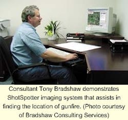
Trilon Technologies incorporated aerial images and automatic telephone notification into the ShotSpotter system, which enhances system usefulness. For this integration task, the company called upon Tony Bradshaw, president of Bradshaw Consulting Services (Aiken, SC). "The ShotSpotter system was linked to The Communicator, an automated telephone notification system from Dialogic Communications (Franklin, TN)," says Bradshaw. "The combined system automatically notifies and solicits residents close to the gunfire as witnesses to the shooting."
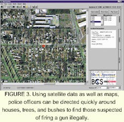
Better still, the addition of aerial images and maps of the area provides responding police officers with detailed descriptions of where the gunfire emanated. "For example," says Bradshaw, "the system can now inform police that gunfire has occurred beside bushes at the back of a garage."
Using Microsoft Visual Studio, Access databases, and ActiveX Data Objects (a Microsoft Data Access component), Bradshaw developed a system running under Windows NT that automatically generates the names, addresses, and phone numbers of the homes and businesses close to the gunfire. The Dialogic Communicator system uses this database to automatically notify nearby residents.
MapObjects 2 from the ESRI and MrSID (Multi-Resolution Seamless Image Database) from Lizardtech (Seattle, WA) were integrated into the system to provide the police with street-level maps and aerial photographs displaying the gunfire's location (see Fig. 3). "With nearly 50 programmable ActiveX automation objects that can be plugged into Windows' development environments, such as Visual Studio, MapObjects is an ActiveX control that integrates dynamic maps into these types of applications," says Bradshaw. "Data from any projection can be combined into a common projection for viewing and analysis, and any map layer can be exported into a new projection," he says.
To optimize system capability and display satellite imagery, MapObjects was integrated with the ESRI's ArcInfo projection engine. The resulting design displays standard GIS formats, such as ArcInfo coverages and ESRI shapefiles, and image formats such as GeoTIFF, TIFF, JPEG, GIF, ERDAS, and MrSID.
The MrSID database produces mosaic imagery for display on the ShotSpotter system, according to Bradshaw. The software, which is a wavelet-based imaging technology, can reduce file sizes down to 95% while maintaining geometric accuracy and providing real-time viewing, panning, and printing of imagery files larger than 1 Gbyte. In the final system design, the combination of ShotSpotter acoustic monitoring, GIS mapping, a database system, and automated notification capabilities provides police with an effective monitoring tool for detecting and locating gunfire in specified areas.
"Using the GIS interface as the primary user interface improves communications by providing the LASD with a single, automated source for geographically notifying nearby residents and extracting contact information," says Bradshaw. Messages are delivered to multiple recipients—from a small group to thousands—within a short time. The GIS interface also enables dispatchers to order calls made in close proximity to the incident.
COMPANY INFORMATIONBradshaw Consulting ServicesAiken, SC 29803Web: www.bcs-gis.comDialogic Communications Corp.
Franklin, TN 37064
Web: www.dccusa.com
Environmental Systems Research Institute
Redlands, CA 92373
Web: www.esri.com
Lizardtech
Seattle, WA 98104
Web: www.lizardtech.com
Microsoft
Redmond, WA
Web: www.microsoft.com
National InstrumentsAustin, TX 78759
Web: www.ni.com
Trilon Technology LLC
Los Altos, CA 94022
E-mail: [email protected]
US Geological Survey
Menlo Park, CA 94025
Web: www.quake.wr.usgs.gov
