YellowScan LIDAR system is designed for UAV remote sensing applications
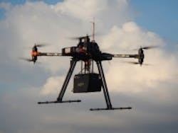
The YellowScan standalone LIDAR system (pictured above on a UAV) was designed by L'Avion Jaune specifically for surveying solutions for UAVs and other small aircraft. The system features a Class 1 laser with a 905 nm wavelength with a maximum range of 100 m and a range resolution of 4 cm. The scanner has a field of view of 100° and is able to capture 40,000 shots per second. YellowScan also comes with software to produce geo-referenced point clouds, which is aided by an integrated Ellipse-E miniature inertial navigation sensor from SBG SYSTEMS, which helps with obtaining a clear and accurate point cloud. Additionally, YellowScan features an on-board computer, integrated battery, connection to external GPS and odometer, IP68 enclosure, and a 200 Hz output rate.
To Learn More:
Contact:L'Avion Jaune
Headquarters: Montferrier sur Lez, France
Product: YellowScan standalone LIDAR system
Key Features: Class 1 laser with a 905 nm wavelength, maximum range of 100 m, range resolution of 4 cm, Ellipse-E miniature inertial navigation sensor, point cloud software.
What L'Avion Jaune says:
View more information on YellowScan.
View More Products| Locate a vendor or system integrator | Receive e-mail updates
Share new products that you think are particularly interesting or helpful by contacting James Carroll, Senior Web Editor, Vision Systems Design.
Join our LinkedIn group | Like us on Facebook | Follow us on Twitter | Check us out on Google +
About the Author

James Carroll
Former VSD Editor James Carroll joined the team 2013. Carroll covered machine vision and imaging from numerous angles, including application stories, industry news, market updates, and new products. In addition to writing and editing articles, Carroll managed the Innovators Awards program and webcasts.