Low cost method maps vegetation in 3-D
Researchers at the Department of Geography and Environmental Systems at the University of Maryland (Baltimore, MD, USA) have proposed an inexpensive way to create 3-D maps of vegetation.
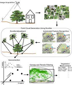
Currently, the standard way to make such high spatial resolution measurements of vegetation has required the use of bulky Light Detection and Ranging (LiDAR) equipment mounted on commercial aircraft.
But the Maryland researchers have demonstrated that it is possible to make high spatial resolution 3-D measurements of the structure of vegetation -- together with associated spectral characteristics -- by applying open-source computer vision algorithms to ordinary digital photographs acquired using inexpensive hobbyist aerial platforms.
Recently, the University of Maryland awarded the researchers a grant to develop a software toolkit called Ecosynth based on the concept.
The open-source 3D Ecosynth toolkit will be offered as an open-source development resource on the Ecotope.org community website here to enable other researchers to also acquire images from the ground and air as well as to rapidly generate high-spatial resolution geo-referenced 3-D scans.
-- by Dave Wilson, Senior Editor, Vision Systems Design