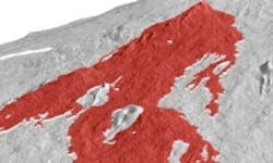
Laser scanning and 3D imaging shows lava flow patterns
Scientists from the University of Oregon have utilized laser scanning lidar technology to capture aerial images of volcanoes which in turn are used to produce 3D models that recreate the internal structure of lava flow.
As it stands now, lava flows are difficult to study because of their dangerous nature, and satellite imagery—which is traditionally used to study the flows from above—often lacks the resolution and image quality needed to study the flows in detail, especially when clouds or trees obstruct the view, according to Livescience. With the lidar technique, the researchers are reportedly able to digitally extract trees and other objects from the images, providing a clear, high-resolution image for analysis.
Airplanes equipped with thousands of lasers scan the terrain at a perpendicular angle to the ground and the length of the laser beams indicates the height of the flow, and when multiplied hundreds of thousands of times, the scans can be compiled into 3D models that recreate the structure of the flow. 3D models of the remains of two previous volcano eruptions in Hawaii were created, which, according to team member Kathy Cashman, enables the team to study old flows and creates new opportunities to monitor active flows.
The data gathered by the geologists at the University of Oregon will enable hazard-mitigation teams to prepare vulnerable communities for future lava flows. It may also add to the body of information that these groups use to predict the behavior of flows, including the speed and direction of potentially damaging tributaries, according to Livescience.
"No one has ever tried to look at where the lava is going within the flow in terms of places where it is thickening versus thinning, so this is a more complete view," Dietterich told LiveScience. "It's not a cross section, and it's not an estimate on top of an old topographic map, which is what you usually have."
The University of Oregon team’s project will be published in an American Geophysical Union Monograph on Hawaiian volcanoes in 2014.
View the Livescience article.
Also check out:
Five machine vision applications to keep an eye on in 2014
X-Motion machine vision system provides autonomous driving for warehouse vehicles
Keyence releases Time of Flight laser sensors
Share your vision-related news by contacting James Carroll, Senior Web Editor, Vision Systems Design
To receive news like this in your inbox, click here.
Join our LinkedIn group | Like us on Facebook | Follow us on Twitter | Check us out on Google +
About the Author

James Carroll
Former VSD Editor James Carroll joined the team 2013. Carroll covered machine vision and imaging from numerous angles, including application stories, industry news, market updates, and new products. In addition to writing and editing articles, Carroll managed the Innovators Awards program and webcasts.
