Military system uses image mapping for target simulations
Military system uses image mapping for target simulations
By John Haystead, Contributing Editor
Developed as a mission rehearsal and planning system for the US Navy, the deployable Tactical Operational Preview Scene (Topscene) data/image graphics system under development by Lockheed Martin Vought Systems (Dallas, TX) provides photo-based image generation of geospecific and feature imagery at fast frame rates for real-time simulations over large terrain databases. The Navy expects to use the system initially in the delivery of aircraft-launched guided munitions and later for autonomous weapon-system simulation and programming.
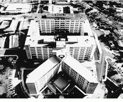
The Topscene system combines high- and low-altitude images from classified satellite data to replicate terrain in a three-dimensional (3-D) graphical format (see Fig. 1). Managing and displaying terrestrial databases at 30 frames per second, the system simulates aircraft speeds from 0 to 1600 knots at altitudes from ground level to 50,000 feet. Features such as buildings, trees, bridges, fortifications, moving vehicles, and aircraft are all replicated in three dimensions.
Database construction
Data from photographs, sensors, and satellites obtained by the Defense Mapping Agency are used for the Topscene database. "[Two-dimensional] image data are available for locations worldwide," says Vought Systems`s program manager Elliott Mattlage, "and are only converted to three dimensions for specific military projects." To generate Topscene databases, Onyx2 workstations (Silicon Graphics Inc.; Mountain View, CA) are used and are located at the Naval Strike Air Warfare Center (Fallon, NV) and at Vought Systems.
"To generate the databases," says Gerry George, Vought Systems`s manager of rehearsal and simulation, "a two-dimensional (2-D) mosaic of the area of interest is created first. Standard Defense Mapping Agency images cover an area roughly 37 miles square, but to create the level of detail, specific 5-m swath patches are added." In the last step, buildings, trees, and targets are overlaid onto the 2-D data to create the final 3-D database.
Based on previous work, converting satellite data of a specific country to a 3-D graphical format typically requires 50-100 Gbytes of data storage, depending on the number of high-resolution areas included. The amount of time required to construct a virtual model is also based on the complexity of the location. "Using one workstation, 10 ¥ 10 nautical miles of terrain can be processed in about four hours. But, because the system can construct only models of buildings at about a six-building-per-hour rate, built-up areas require a longer time," notes Mattlage.
Final model data are compressed at a 4:1 ratio and stored on 4.3-Gbyte digital disks or 8-mm tape for transfer to deployed systems. "Because of data size, it is not yet efficient to transfer data electronically. However, as [imaging] systems containing more bandwidth are deployed, this will be possible," says Mattlage. In fact, scenario update packages, such as specific target information, are being transmitted electronically, and the deployed system can also be updated in the field using locally collected data.
Off-the-shelf hardware
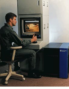
Built from off-the-shelf hardware, the Topscene system uses 12 removable, hot-swap storage-drive units, with a total storage capacity of 200 Gbytes, configured in a rugged tower console (see Fig. 2). The operator`s display can be either a 1280 ¥ 1024 or a 1920 ¥ 1200 monitor. Al though the system is capable of displaying 32-bit/pixel color im ages, most de ployed systems display monochrome images generated at 8 bits per pixel. In frared (IR) im age data are displayed using 16- or 24-bit words.
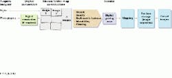
Installed under the storage-drive units is an Onyx2 workstation that uses stick and throttle controls for flight simulation. Powered by four 195-MHz MIPS R10000 processors, the workstation is capable of rendering 11 million polygons/s. It is used to continually access the 2-D mosaic, elevation, and feature databases and to automatically compute new perspectives for operators. The mosaic imagery is obtained from discrete, digital, or photographic images up to 18k ¥ 18k pixels by means of special image-processing software. This software implements mosaic/orthogonal map construction, rectification, and radiometric balancing (see Fig. 3).
By overlaying a configurable instrument panel on a virtual head-up display (HUD), the operator is simultaneously provided with rate of climb, threat status, airframe position, and altitude information, while a 2-D moving-map display updates order-of-battle information. Operators also can configure the system to simulate day or night scenes, induce fog or haze conditions, or introduce night-vision settings.
Layered software
The Topscene 4000 system runs Silicon Graphics Iris Performer and Paradigm Simulation (Dallas, TX) Vega simulation software packages. Custom C++ system software added to the software allows images to be displayed on the HUD unit. Additional tactical-application software packages that incorporate functions such as graphical overlay of threat information and infrared and night-vision goggle simulation are being developed by Vought Systems.
Although the Topscene system is slated for mission-rehearsal procedures, the system will, in the future, be used to program autonomous weapon systems such as cruise missiles. But, because cruise missiles use narrow field-of-view IR seekers to locate and identify targets, sufficiently detailed 3-D, IR-image databases must be added to the system.
In the past, IR data sets have not provided enough resolution to replicate the images captured by narrow-field-of-view IR sensors. To obtain higher resolution, Vought Systems is combining its electro-optical image database with infrared-signature models to generate IR image databases. An additional model of anticipated changes in the IR environment and object-signature characteristics are then overlaid onto a static 3-D map. Based on object and terrain radiance files, a dynamic representation of the expected infrared view of an area at any time of day or weather conditions is therefore expected to be created.
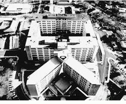
FIGURE 1. The Tactical Operational Preview Scene (Topscene) image-mapping system, under development by Lockheed Martin Vought Systems, provides three-dimensional images of photographic-quality detail that are updated at real-time display rates. Here, the displayed area shows Georgetown University in Washington, DC, part of which is recognized by the "upside-down" V-shaped building at the right.
FIGURE 2. The Topscene Model 4000 system incorporates off-the-shelf products such as a Silicon Graphics Onyx2 Infinite Reality Workstation and removable storage-drive units configured in a tower console. The stick and throttle controls enable the operator to simulate fly-throughs or walk-throughs of integrated imagery based on selected menu options and various initial conditions.
FIGURE 3. Capable of generating mosaic images from digital and photographic imagery, the database section of the Topscene system uses interacting image-processing software to generate multiperspective vertical, oblique, and omnidirectional images. For example, overhead images of a specific terrain object, such as a building, can be converted to perspective scenes viewed from two angles. The databases are developed from photographic, sensor, and satellite information and are stored on removable digital disks for worldwide use.


