Drones Rely on Sensors to Perform Better and Become More Useful
Aerial drones have become indispensable in many applications, such as agriculture, real estate, and cinematography. Yet, as widely adopted as they already are, drones still have almost unlimited potential. Additional uses can include delivery, inspection, search and rescue, monitoring, mapping, and more.
In fact, the global commercial drone market was valued at $2.7 billion in 2020, according to Allied Market Research in a February 2022 report, and is projected to reach $21.69 billion by 2030, which would be a CAGR of 23.7%.
Fundamental to drone utility is sensor technology. Drones benefit from a wide range of sensors just for their own flight and navigation. Their ancillary capabilities depend on sensors, including camera, motion detectors, heat sensors, and so on.
Eyes in the Sky
The popularity of aerial drones is based significantly on their ability to loft cameras. Manufacturers are still churning out models designed to allow users to attach a smartphone or a discrete video camera, but drones with built-in cameras are becoming more common.
There are many visual-based tasks for which drones could be used. For example, inspecting the structural integrity of structures that are hard for humans to physically reach—bridge trusses, remote pipelines, and communications towers, for example.
There are many imaging sensors that can be built into, or mounted, on drones to achieve a wide range of goals. Optical sensors that detect the visible light spectrum capture still images and video, infrared sensors detect heat patterns, and radars and LiDARs are useful in mapping terrain.
Some examples of combining imaging sensors include:
- Examining the structural integrity of both engineered and natural structures
- Tracking livestock
- Measuring aridity or water saturation in a geographic area
- Evaluating crop health
- Detecting and tracking forest fires
- Aiding in search and rescue operations
As a practical matter, these sensors are often attached to drones, rather than being built in, but that doesn’t undermine the value of com films, or to one day detect a hairline crack in a bridge or a loose connector in a wireline, depends on holding sufficiently still in flight regardless of environmental conditions.
Keeping Cameras Steady
The ability to use a drone for overhead shots in feature films, or to one day detect a hairline crack in a bridge or a loose connector in a wireline, depends on holding sufficiently still in flight regardless of environmental conditions.
The ability to hold steady sounds like one performance capability, but it’s actually two: image stabilization for the cameras themselves and holding the drone steady in flight. Each capability relies on a different set of sensors.
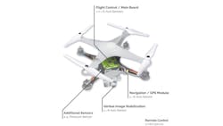
Electronic image stabilization (EIS) and optical image stabilization (OIS) sensors were developed to improve camera performance in smart phones by compensating for movement, jostling, and vibration. Originally employed in smartphones, these stabilizing technologies are now being incorporated in other devices to help keep video imagery steady, including drones.
EIS compensates for motion in software using IMU (inertial measurement unit) sensor data; the approach is to capture image data from the sensors and then apply software techniques to compensate for any distortions caused by the imaging sensor being moved. OIS compensates for motion in the hardware; the approach is to analyze the motion experienced by the optical sensor then physically manipulate the camera to compensate for the motion. These techniques can be used in tandem.
OIS/EIS data can also be used for flight stability in drones that use optical sensors for vision-based localization and obstacle avoidance.
Sensors for Drone Operation
Modern drones impress with how smoothly some of them can fly—just think of all the long, steady aerial tracking shots that have become common in movies and television shows.
Precision flight in drones is dependrpdent largely on IMUs. IMUs typically combine a three-axis accelerometer and a three-axis gyroscope to provide drones with the data necessary to maintain stable flight.
Many advanced drones are built to work with satellite navigation systems such as GPS, and so they include IMUs for dead reckoning. Dead reckoning is a navigation process that calculates the position of a moving object, such as a drone, using its previously determined location paired with data about the object’s velocity (both speed and direction) and elapsed time. This is useful to address any gap in GPS availability as well as provide fast position and orientation update rate information as needed for drone control. It can similarly be used with other indoor applications with navigation solutions for augmentation; an underground mining application is an example where the integration of an IMU is necessary. Dead reckoning techniques are also used as a last resort backup for graceful degradation action (such as safe landing), if primary navigation systems fail.
Some of the new use cases for drones will necessitate stricter safety requirements than have been applied to drones thus far. As an example, drones used for package delivery in populated cities cannot fail in flight, should not go astray, and need to avoid hard, awkward landings, regardless of the fragility of their cargo.
This increased level of dependability and accuracy will also apply as drones increasingly get used indoors—to monitor lines or pipes in automated factories—for example, or in places where they might operate near humans— in warehouses, for instance. Precision, accuracy, and reliability will all be greater priorities moving forward.
IMU technology continues to be improved, which will improve the accuracy of drone navigation and flight. Meanwhile, any drone can incorporate multiple IMUs for improved performance and system redundancy.
IMUs can also be supplemented with other sensors to improve drone flight and navigation. For example, pressure sensors can provide indications of altitude. Being able to determine altitude is obviously useful in aerial navigation, but regulatory agencies are establishing flight ceilings for drones and the ability to determine altitude would allow drone manufacturers and drone operators to program limits on how high their drones can ascend.
Altitude data from pressure sensors could also be used to aid in landing. In addition, a bottom-mounted ultrasound sensor could provide an even more precise measurement of how far a drone is hovering above a delivery platform. These ultrasound sensors, more commonly referred to as time of flight (ToF) sensors, have accuracy within centimeters and should prove useful in helping autonomous drones consistently achieve gentle landings.
ToF sensors can be used to improve autonomous drone navigation by aiding with object detection and avoidance. They are good at detecting glass windows and identifying water, which is useful for determining where not to fly and land.
Drones maneuver by adjusting the spin rates of their multiple rotors relative to each other. Some drone manufacturers use optical encoders to measure the spin rates of the rotors, and use that data to improve rotor control, and therefore flight control. But using optical encoders is not the only way to achieve that goal. Magnetometers can be used to accurately measure rotor turn rate at a much more affordable cost point.
Although people began mounting cameras on drones as soon as they were introduced, airborne audio had to wait; the noise emitted by drones themselves overwhelmed ambient sound. Since then, low-power MEMS microphones have been introduced with ample dynamic range to allow even the noisiest drones to capture clear audio when used in conjunction with active noise cancellation (ANC) technology.
It is also possible for drones to use audio data for self-diagnostics; for example, motor impairments can often be identified through unique sound signatures. As drones become more sophisticated and more expensive, the ability to detect system problems through a variety of means is imperative.
The integration of microphones also paves the way for voice control. This feature is getting closer to being included in commercial drone models for remote control.
Drones continue to become more useful as they become more capable and safer; this will continue to accelerate through the integration of a higher volume, wider variety, and stronger performing sensors. Safety is rooted in reliability, which in turn implies high-quality sensors that are accurate and reliable. When designing drones or new drone capabilities, it is essential to consider sensor quality and reliability.


