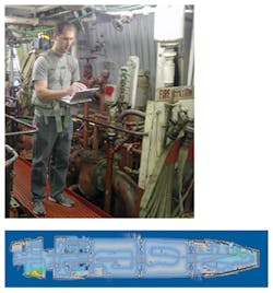
Portable mapping system in a backpack
Engineers from the Applied Physics Laboratory at Johns Hopkins University (APL, Laurel, MD, USA) have developed a portable mapping system carried in a backpack that can automatically create annotated physical maps of locations such as underground areas and ships.
Produced for the Defense Threat Reduction Agency (DTRA; Fort Belvoir, VA, USA), the so-called Enhanced Mapping and Positioning System (EMAPS) captures a floor-plan-style map of the area traversed, as well as 360-degree photos and sensor readings of that area.
The basic EMAPS unit is an approximately six-inch cube that weighs less than four pounds, and includes a laser scanner that measures the distances to walls and features in the environment.
EMAPS has been designed mainly to detect and map environmental threats. Software on the system associates critical environmental data, such as radiation or radio frequency signal levels, with map locations.
EMAPS has already collected more than 100 hours of mapping data from a range of environments, including ships, underground storage facilities, army training areas, and buildings such as the Smithsonian Natural History Museum.
Related items from Vision Systems Design that you might also find of interest.
1. Flash lidar could help planes refuel
Researchers at Advanced Scientific Concepts (Santa Barbara, CA, USA) have proposed using a novel tracking method to establish the relative position and orientation between such a UAV and the drogue carried by a refueling aircraft.
2. Irish cliffs surveyed with Lidar
When chartered land surveyors at Coastway (Co. Kildare, Ireland) were given the task of laser scanning and producing a 3-D model of the cliffs of Moher on the western seaboard of County Clare Ireland, they approached Measurement Devices Ltd (MDL; York, England) to assist them with the task.
3. Lidar unveils possible Honduran archaeological ruins
A team from the University of Houston (UH; Houston, TX, USA) and the National Science Foundation (NSF) National Center for Airborne Laser Mapping (NCALM; Houston, TX, USA) has mapped a remote region of Honduras that may contain the legendary lost city of Ciudad Blanca.
4. Lidar optimizes wind turbine output
Working with engineers from the National Renewable Energy Laboratory (NREL; Boulder, CO USA), scientists from the University of Stuttgart (Stuttgart, Germany) have developed a control system that can optimize the energy extracted from wind turbines.
-- Dave Wilson, Senior Editor, Vision Systems Design
