Experimental VNIR/SWIR UAV-based imaging system developed for vegetation analysis
Researchers from the Application Center for Machine Learning and Sensor Technology at the University of Applied Science Koblenz (Koblenz, Germany; www.hs-koblenz.de) and the Institute of Geography, GIS & RS Group, at the University of Cologne (Cologne, Germany; www.portal.uni-koeln.de) developed a new UAV-based multi-camera imaging system that uses visible-to-near-infrared (VNIR) and shortwave infrared (SWIR) wavelengths simultaneously for use in forage mass monitoring.
While UAVs are often equipped with hyperspectral/multispectral cameras for the purpose of crop health monitoring, according to the authors of the study “Development of a VNIR/SWIR Multispectral Imaging System for Vegetation Monitoring with Unmanned Aerial Systems” (bit.ly/VNIRSWIR-UAV), SWIR systems, with only a few exceptions, are typically not employed in these applications owing to expense, weight, and/or poor performance. The most common systems are sensitive in the VNIR wavelength range of 350 to 1000 nm.
The researchers therefore created a 2D two-channel multispectral imaging system with broader sensitivity to the SWIR spectrum, from 600 to 1700 nm, that was appropriate for UAV deployment. Creating the system would allow the researchers to study the efficacy of widening the available wavelengths for analysis when monitoring vegetation, compared to the more limited, established wavelength ranges commonly in use.
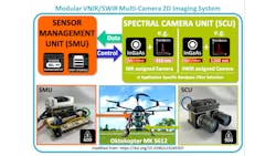
The system is designed modularly to fit a wide variety of UAV models and on the backend to allow for expansion into sensing more than two wavelength bands. The first module, the Spectral Camera Unit (SCU) includes two OWL 640 M VIS-SWIR SWaP camera modules from Raptor Photonics (Larne, Co. Antrim, UK; www.raptorphotonics.com), each featuring 640 x 512 resolution and 15 µm pixel size.
The cameras mount Kowa (Düsseldorf, Germany; www.kowa-lenses.com) LM12HC-SW lenses with 12.5 mm focal length. The researchers designed a custom C-Mount flange in order to place hybrid bandpass filters for the NIR and SWIR spectral ranges between the camera lens and the image sensor, to reduce possible blue shift and image artifacts introduced by traditional filter front-mounting methods. A custom-designed, 3D-printed mounting plate for the camera modules maintains precise parallel alignment and is intended to make for easy mounting and alignment onto gimbals or tripods.
The second module, the Sensor Management Unit, houses the other system hardware. The cameras output 14-bit images to a dual CameraLink frame grabber from EPIX (Buffalo Grove, IL, USA; www.epixinc.com) installed into a custom mounting bracket and connected via PCIe to an NVIDIA (Santa Clara, CA, USA; www.nvidia.com) Jetson TX2 SoM running Ubuntu 16.04. An Elroy carrier board from Connect Tech (Guelph, ON, Canada; www.connecttech.com) provides interfaces for the frame grabber and a 128 GB mSata SSD.
The complete system was mounted on a Mikrokopter MK 6S12 unmanned aerial vehicle (UAV) from HiSystems GmbH (Moormerland, Germany; www.mikrokopter.de). After successful testing at the Institute of Geography at the University of Cologne, the researchers employed the new imaging system for another study, “Investigating the Potential of a Newly Developed UAV-based VNIR/SWIR Imaging System for Forage Mass Monitoring” (bit.ly/VSD-VNIRSWIR).
The study was conducted in late July 2019 in permanent grasslands about 30 km southeast of Cologne designed for experiments. A total of 156 plots were arranged in a chessboard pattern. Three different nitrogen fertilizer application levels and control plots with no fertilizer were present in the test field. An ASD FieldSpec3 spectroradiometer from Malvern Panalytical (Malvern, Worcestershire, UK; www.malvernpanalytical.com) was used to record results for comparison to the UAV-based data. Dry matter (DM) yield ground truth data was also measured via destructive tests. For these tests, the imaging system was mounted on an MK S612 Oktocopter UAV from HiSystems GmbH.
The data gathered by the UAV and the spectroradiometer were analyzed via a set of vegetation indices, mathematical algorithms of two or more spectral bands to accentuate vegetation properties like leaf area index and chlorophyll content via processed orthomosaics. According to the researchers, the results from the UAV-based system were of high enough quality to demonstrate that their system did have the potential to deliver high-quality spectral data from which vegetation indices could be derived. Furthermore, the study results justify future research with longer test periods and other, more robust testing measures.
About the Author

Dennis Scimeca
Dennis Scimeca is a veteran technology journalist with expertise in interactive entertainment and virtual reality. At Vision Systems Design, Dennis covered machine vision and image processing with an eye toward leading-edge technologies and practical applications for making a better world. Currently, he is the senior editor for technology at IndustryWeek, a partner publication to Vision Systems Design.