Vision-Assisted Underwater Drones Used to Investigate Environmental Issues on Coral Reef
A team of researchers recently completed a survey of Hall Bank, a small, nearshore coral reef off the coast of southwestern Australia. This project was a result of a collaborative effort between Advanced Navigation (Sydney, NSW, Australia), a company specializing in navigation and autonomous systems, and O2 Marine (Fremantle, WA, Australia), a marine environmental and oceanographic consulting company.
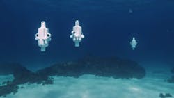
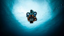
The team deployed three Hydrus drones, designed and built by Advanced Navigation, to study the reef for environmental issues. Hydrus is a micro hovering autonomous underwater vehicle especially designed for such uses as underwater surveys and inspections. Equipped with a high-resolution camera and sensors, the drones can be programmed to traverse patterns and routes in order to collect video and high-resolution image data.
For this mission, the drones were programmed to execute coordinated transects and lawnmower survey patterns across different sections of the reef. Once the drones finished the mission and the team retrieved them, the image data was transmitted via WiFi to a computer at an onshore facility, loaded with Agisoft Metashape (St. Petersburg, Russia), a software that transforms photos into 3D models using photogrammetric processing,to develop a digital twin of the reef.
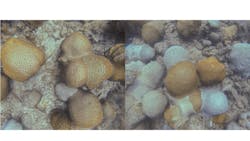
With the digital twin, the team was able to see and locate evidence of environmental issues, such as bleaching and fragmentation of the coral.
The following is a Q&A with Alec McGregor, Senior AI Engineer with Advanced Navigation.
Please tell us more about the roles and goals of Advanced Navigation and O2 Marine in the Hall Bank survey.
McGregor: As a marine consulting company, O2 Marine’s ambition lies in aiding businesses to accelerate efforts in marine environmental assessment and monitoring, marine fauna, and oceanography. As O2 Marine looks to secure new business opportunities and expand global conservation efforts, they need to enhance the accuracy and depth of their own environmental and sustainability analyses. This necessitates the use of advanced technology that captures both the scale and the fine detail of change beneath the ocean surface.
This is where Hydrus came in. The survey was carried out collectively by Advanced Navigation and O2 Marine, with a goal to demonstrate Hydrus’s capability to collect data and insights for knowledge-sharing in a cost-effective way. After the underwater survey, Advanced Navigation worked on post-processing the data captured on Hydrus and building a 3D digital twin.
Related: Researchers Develop 3D Model for Underwater Mapping Applications
Please explain how the Hydrus collects the data you needed for this project.
McGregor: Hydrus is equipped with advanced sensors and a 4K camera to capture high-resolution, geo-referenced imagery and video. Post-mission, the data was extracted from Hydrus, then uploaded to a computer for post-processing.
Missions on Hydrus can be set up using the mission-planning software. Once in the water, Hydrus is able to follow the pre-programmed path and execute missions fully autonomously. For each image and video frame it captured, we would get a geo-referenced position for it, which is difficult to do underwater via traditional surveying methods. Using this data, we are able to create geo-referenced models.
Hydrus’s onboard inertial navigation system (INS) draws on sophisticated algorithms developed by Advanced Navigation. Built with a multitude of ultra-sensitive sensors, the INS provides consistent position and attitude data. It dynamically weighs each sensor input, adjusting in real time based on reliability scores, environmental conditions, and operational context. This ensures continuous, high-confidence state estimation and navigation in the underwater environment, where satellite signals are lost.
Related: Drones, High Resolution Cameras Boost inspection Safety and Quality
What hardware was used?
McGregor:
· Camera: 4K, 12 Mpixel resolution with 60 fps frame rate
· Lighting: 5,000 lumens
· Camera Housing: Vertically integrated pressure vessel
· Communications: Subsonus USBL² acoustic positioning, GNSS Compass, WiFi (above water)
How and where is the digital twin developed?
The digital twin was developed in Advanced Navigation’s subsea robotics centre in Perth, Western Australia. Over 1,000 still images were stitched together to create a 3D replica of the area
What were some technical challenges you had to overcome and how did you address them?
McGregor: One major hurdle was maintaining accurate positioning in areas with weak GNSS signals or reduced DVL[LW1] [JT2] ( Doppler Velocity Logger, an instrument that measures speed and direction of an underwater vehicle relative to the sea bottom) and acoustic performance, especially near coral reefs and other complex subsea environments. We also had to carefully balance survey resolution with mission duration, which required meticulous pre-planning to ensure we captured high-quality imagery without exceeding operational limits.
Environmental variability, especially current-induced drift, also posed a significant challenge. This necessitated both real-time corrections and thoughtful mission-planning to maintain consistent coverage and image quality.
Did the project accomplish its goals?
Yes. Hydrus was able to systematically map the reef’s structure and condition, capturing the fine-scale changes in coral health that are often missed by traditional survey methods. Given the results, O2 Marine will integrate Hydrus into critical real-world projects for impact assessment investigations with its global partners.
Related: Robotic Vehicle Plunges Into Ocean Exploration with an Optical Sensing Platform
About the Author

Jim Tatum
Senior Editor
VSD Senior Editor Jim Tatum has more than 25 years experience in print and digital journalism, covering business/industry/economic development issues, regional and local government/regulatory issues, and more. In 2019, he transitioned from newspapers to business media full time, joining VSD in 2023.