Drone-Based Water Intelligence System Utilizes SWIR and NIR Vision and AI
Key Highlights
- The drone mounted system integrates quantum dot SWIR and NIR sensors with AI for real-time moisture detection from drones.
- The system can generate high-resolution (up to 2 cm per pixel) moisture maps, bridging the gap between satellite and ground level sensors
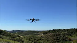
Quantum Solutions (Cambridge. UK), an imaging technology company specializing in manufacturing quantum dot short-wave infrared (SWIR) sensors, has partnered with Delmar Aerospace Corporation (Las Vegas, NV, USA), an unmanned aircraft systems company, and Delmar subsidiary Perspectum Drone Inspection Services (Alberta, CA) to develop and deploy a drone-based system that utilizes non-visible wavelength cameras and AI software to provide high-resolution water intelligence services. Plans call for these drones to be deployed across the western U.S. and parts of Canada, according to a joint press release from Quantum, Delmar and Perspectum.
The drones, built by Delmar and operated by Perspectum, are equipped with Quantum Solutions’ Q. Fly Water system, which includes quantum dot SWIR and NIR sensors, an onboard edge computer processing unit, and a live visualization interface for the drone pilot.
Related: Drones, High Resolution Cameras Boost Inspection Safety and Quality
What Is Moisture Intelligence and Why Is it Important?
Moisture intelligence refers to the collection and use of flow, pressure, and volume data; water quality metrics; and weather, climate, and watershed data. It has become an important source of information for many industrial sectors, including agriculture, infrastructure maintenance, and manufacturing. For example, AI infrastructure and data centers are driving rapid growth in water demand, making moisture intelligence critical to both sustainability and business, according to the World Economic Forum.
A Jan. 14, 2026, article from WEF noted that, “Water underpins the AI super cycle’s entire value chain… Right now, the AI economy consumes 23 cubic kilometers of water a year. By 2050, this is predicted to more than double (up 129%) to more than 54 cubic kilometers (14 trillion U.S. gallons), according to new research by Global Water Intelligence and Xylem. In other words, our world needs to find an extra 31 cubic kilometers of water a year for the AI economy to run. That’s enough to supply every human being on Earth with an extra 3,820 liters of fresh water a year.”
So, with water becoming scarcer and climate pressures/issues increasing, demand is increasing for environmental intelligence that will augment and support better decision-making regarding water conservation and use, said Quantum Solutions CEO Marat Lutfullin in a press release. This partnership, he says, believes that non-visible sensors are an effective means of mining as a yet largely untapped source of important information.
“We believe some of the world’s most valuable data lies beyond the visible spectrum,” Lutfullin stated in a press release.
Components of the Q. Fly Water System
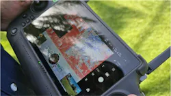
The system, installed onboard a drone, consists of a dual-band camera equipped with NIR and quantum dot sensors, an embedded processor loaded with AI software, and controller screen that displays the NDMI data in real time, said Alexander Bessanov, Quantum Solutions vice president of products, imaging systems. . The software is developed and written by Bessanov’s team.
Historically, cameras utilizing NIR and SWIR bandwidths were rare on the commercial market because they were so cost prohibitive, he noted. However, his team was able to develop and leverage those technologies internally.
“We deliver fairly unique technology,” he said. “We have been able to develop those bandwidths internally and leverage them...We built all the layers, our core technology, basically in-house, starting from sensor production, camera core assembly, and the payload itself. Most of the component elements are built in-house.”
How the System Works
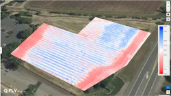
Normalized difference moisture index (NDMI) is the standard index used by satellites to measure available water levels in vegetation and soil. However, satellite NDMI information is limited by factors such as a satellite’s fixed orbit, atmospheric obstacles, such as cloud cover, and a 20 m resolution floor, Bessanov said.
The system is designed to capture and compute NDMI in real time, while the drone is still flying, by detecting data in two water-sensitive non-visible wavebands, NIR and quantum dot SWIR, simultaneously. This reveals moisture contrasts invisible to RGB cameras, or the human eye, at resolutions up to 2 cm per pixel, bridging the gap between coarse satellite imagery and single-point ground sensors, Bessanov said. The system is cloud-based, which enables wireless communication of information in real time, rather than extracting and analyzing data hours or days after completing the flight.
“So, it's a dual-band system, two channels synchronously taking images, so that the core information is registered down to microseconds if not nanoseconds,” Bessanov says. “They're fully synchronized and they capture the same scene and then we calculate the index like a product of these two images.”
With this, the system can produce color-coded moisture maps almost immediately, he said. Generally, blue or green areas on a map indicate higher moisture levels while red or yellow areas indicate lower moisture levels.
Technical Challenges for the Drone System
The system is not without its challenges, Bessanov said. For one, the technology is still fairly new for this type of application, simply because it has been cost prohibitive.
“I think the shortwave infrared technology is still relatively unmatured,” Bessanov said.
Another challenge is that thermal imaging cameras can produce a significant amount of electronic “noise” if they are not cooled. But since these cameras/sensors have to be light enough for a drone to carry them, they do not have internal cooling systems like similar cameras in, say, a factory setting on the ground, he said.
“This produces more thermally generated noise, which means that we spend more time calibrating the cameras for all the various scenarios—for example, for temperatures across a broad range, from 0 or below 0 up to 60 °C.
The cameras also adequately operate in a variety of lighting conditions as well, which can and do change rapidly due to atmospheric conditions, weather, and time of day.
“I think one of the biggest challenges in this industry is spectral unmixing,” Bessanov said. “So, there are several different challenges, for example, recognition, detection, and particularly, identification. You need to identify the chemical composition of the materials, and we solve this challenge by providing the tool for visualizing water moisture, which is otherwise impossible to see with other tools.”
About the Author

Jim Tatum
Senior Editor
VSD Senior Editor Jim Tatum has more than 25 years experience in print and digital journalism, covering business/industry/economic development issues, regional and local government/regulatory issues, and more. In 2019, he transitioned from newspapers to business media full time, joining VSD in 2023.