PHOTOGRAMMETRY: Photogrammetric techniques date historic film
On April 18, 1906, the city of San Francisco, CA was largely destroyed by an earthquake and resulting fire. Before this tragic event occurred, an undated film entitled A Trip Down Market Street pictured the city as it was at the turn of the 19th century (http://bit.ly/cpScfJ).
According to the Library of Congress (Washington, DC, USA; www.loc.gov), the original film was created in early September 1905, a fact later disproven by film historian David Kiehn. In research based on license plate and other records, Kiehn determined that the film must have been made in the spring of 1906.
To more accurately determine the date of the filming, Richard Greene of Bio-Rad Laboratories (Hercules, CA, USA; www.bio-rad.com) has now taken up the challenge using photogrammetric analysis to determine that A Trip Down Market Street was most likely filmed from March 24–30, 1906, three weeks before the fire and earthquake of April 18 (Photogrammetric Engineering & Remote Sensing, August 2011).
Greene used a number of different indicators apparent in two digitized versions of the film to arrive at this conclusion. At the end of the film, the tower clock of San Francisco's historic Ferry Building shows a time of 3:17 PM Pacific Standard Time (PST), which is confirmed in the Library of Congress description.
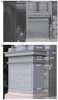
However, to determine the time of year in which the film was taken, the position of the sun in the sky needed to be found. Luckily, a number of objects are clearly visible in the film that cast shadows, and one of them—the Ferry Building cornerstone—still exists today. By digitizing these images and measuring the shadows, Greene determined the approximate date of the film.
Relative dimensions of the shadows present on the cornerstone were then measured in pixel values and correlated with known measurements to determine real-world values (see figure). Although the cornerstone of the building is not parallel to the camera plane in the film, the less than 10° difference resulted in a small fraction of a pixel in the digitized images and found insignificant compared with any subsequent measurement error. Since the position of the building facing approximately 36° south of due west is known, these real-world shadow values could then be used to calculate the azimuth and elevation of the sun.
Using a spreadsheet from the National Oceanographic and Atmospheric Administration (NOAA; Washington, DC, USA; www.noaa.gov), the angle of the sun at a specific time of year can be calculated for any given latitude. Since the Ferry Building is at a known latitude and longitude, the position of the sun was then determined over a range of dates covering the period May 1905 to April 1906. While Greene found a match for just the solar elevation in September 1905, the azimuth and solar elevation only matched from March 24–30, 1906.
While these findings are consistent with those found by Kiehn, they are inconsistent with the data of April 11 given in the advertisement for the film and with the date of April 14, 1906 quoted in the Internet Movie Database (www.imdb.com).


