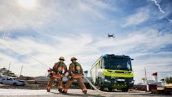
Firefighting equipment manufacturer partners with DJI to provide aerial drone camera footage for first responders
In this week’s roundup from the Association for Unmanned Vehicle Systems International, which highlights some of the latest news and headlines in unmanned vehicles and robotics, firefighters will gain new levels of situational awareness thanks to aerial drone camera platforms, the National Oceanic and Atmospheric Administration (NOAA) establishes a new Unmanned Systems Operations Program, and drone flight permissions expand in Quebec, Canada.
DJI, Rosenbauer International AG partner to enhance emergency response efforts
DJI has announced a new strategic partnership with fire service vehicles and firefighting equipment manufacturer Rosenbauer International AG.
Through their collaboration, the companies will provide anyone involved in being called to address an emergency situation with the benefits of digital emergency response management, through the combination of an aerial perspective with Rosenbauer's operation management system. The combination will enable the quick assessment of situations, and for informed decisions to be made regarding the safest and most efficient deployment of personnel.
“DJI is proud to bring its drone technology to support Rosenbauer’s excellence in fire apparatus manufacturing and its vision of empowering firefighters with the best possible tools for emergency response and disaster relief,” says Roger Luo, President, DJI.
“This integration is an important step for this long-term partnership, and our commitment demonstrates an increasing maturity in the adoption of drones for firefighting professionals.”
The information management system for firefighting operations, Rosenbauer's operation management system supports emergency crews on site with relevant information such as fire safety maps, hazardous material data or vehicle rescue sheets. Data from FlightHub, which is DJI’s drone fleet management software, will be integrated into Rosenbauer's operation management system, providing the decision maker of the operation with additional visual and thermal data.
To provide a full overview of the situation, this information can then be relayed to operational units at the scene on a tablet or displayed on monitors back at the command center, allowing for informed decisions to be made in real time regarding the efficient and safe deployment of resources such as personnel, vehicles and other equipment.
A server in the highly secure computer center of a well-known European telecommunication firm will be used to store all information that is delivered to the Rosenbauer operation management system in real-time, as well as from DJI's FlightHub. The data traffic is secured and encrypted. Data is also synced with all mobile end devices during the deployment, so that every operational team has the same information, and it is kept in a closed loop.
“Speed and a truly complete overall picture are key criteria for success when emergency service teams have to make purposeful decisions under time pressure. We have already supported their efforts to meet these criteria with our IT solutions, which range from efficient vehicle management to navigation, right through to alarm applications,” explains Dieter Siegel, CEO of Rosenbauer International.
“This cooperation with DJI enables us to consolidate our role as a digital pioneer while we work together to develop an integrated technology for comprehensive, data-based firefighting and disaster management.”
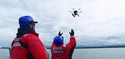
NOAA establishes Unmanned Systems Operations Program to support growing use of UxS across agency
To support the growing use of unmanned systems across the agency, the National Oceanic and Atmospheric Administration (NOAA) is establishing a new Unmanned Systems Operations Program.
According to NOAA, the program will support the “safe, efficient and economical operation” of unmanned systems (UxS) that it uses to collect high-quality environmental data for its science, products and services.
“Unmanned airborne and maritime systems are transforming how we conduct earth science at NOAA,” says retired Navy Rear Adm. Timothy Gallaudet, Ph.D., deputy NOAA administrator.
“Our new Unmanned Systems Operations Program will help us dramatically increase the application and use of these technologies in every NOAA mission area.”
NOAA currently uses unmanned systems for a variety of tasks, including but not limited to, seafloor and habitat mapping, ocean exploration and emergency response. The agency notes that its scientists have been experimenting with and using unmanned systems for decades, but there has been an increase in the use of this technology as a force multiplier for many NOAA programs as a result of the recent surge in availability of these systems. Since 2012, NOAA’s use of small UAS for science missions has increased more than tenfold.
The Unmanned Systems Operations Program is being established within NOAA’s Office of Marine and Aviation Operations (OMAO). Responsible for operating, managing and maintaining the agency’s fleet of ships and aircraft, OMAO also oversees NOAA’s diving and small boat safety programs. Services to be offered under the program will include training, cybersecurity, acquisition and other expert support to ensure safe, cost-effective operations across the agency.
“With the creation of this new program, we will be better positioned to transition these technologies into operational platforms that will gather critical environmental data every American relies upon,” says Rear Adm. Michael J. Silah, director of the NOAA Commissioned Officer Corps and OMAO.
The new program will be housed at two locations. The NOAA Aircraft Operations Center in Lakeland, Florida will continue to support the agency’s UAS activities, while unmanned maritime systems activities will be supported at a new facility being built by the Mississippi State Port Authority in partnership with the University of Southern Mississippi in Gulfport, Mississippi.
In Fiscal Year 2020, NOAA received $12.7 million from Congress to improve and expand UxS operations across the agency, which includes the creation of this new program. NOAA says that the establishment of this program will also help meet the objectives of the Commercial Engagement Through Ocean Technology Act of 2018, which requires NOAA to coordinate research, assess and acquire unmanned marine systems with the U.S. Navy, other federal agencies, industry and academia.
Through the Advanced Naval Technology Exercise (ANTX) program, NOAA and the Navy will collaborate to evaluate new UxS technologies for ocean science applications. Through ANTX, scientists and engineers can participate in the testing and assessment of experimental technologies that can support missions of both agencies. Dozens of new systems are tested and demonstrated during the exercise to help inform government and private sector investment decisions.
Iris Automation, MVT Geo-solutions to conduct BVLOS flights using only onboard Detect-and-Avoid in Canada
Transport Canada has granted Iris Automation and MVT Geo-solutions the first beyond visual line of sight (BVLOS) Special Flight Operations Certificate (SFOC) using only onboard Detect-and-Avoid (DAA).
The approval was granted based on the use of Casia, which is Iris Automation’s DAA system that provides commercial drones with automated collision avoidance maneuvers.
“Achieving the first BVLOS approval in Canada further validates our technology alongside multiple permissions we have already received from regulators in the U.S. and South Africa,” says Iris Automation CEO Alexander Harmsen.
“This technology is critical to safely integrate drones into the airspace along with manned-aircraft, and we look forward to unlocking commercial operations for our customers in Canada.”
The waiver allows flights to be conducted within the UAS Center of Excellence’s controlled airspace Remotely Piloted Aircraft System (RPAS) test range in Alma, Quebec. This will be the first BVLOS flight conducted at the location that utilizes only onboard DAA for air risk mitigation, and does not require ground-based observers or radar.
Iris Automation notes that BVLOS flights unlock autonomous drone use for a variety of commercial applications such as emergency response, infrastructure inspection and package delivery.
“The UAS Center of Excellence is looking forward to leveraging Iris Automation’s industry-leading DAA system and existing flight expertise within our network to conduct BVLOS flights with MVT Geo-solutions,” says UAS Center of Excellence Director William de Keiser.
“We will continue to develop our partnership with Iris Automation to provide training to local operators and enable BVLOS flights in Canada.”
The first BVLOS flights are expected to occur within weeks. Data collected during these flights will inform more complex BVLOS operations in the future.
Compiled by Brian Sprowl, Associate Editor, AUVSI
Share your vision-related news by contacting Dennis Scimeca, Associate Editor, Vision Systems Design
SUBSCRIBE TO OUR NEWSLETTERS