Unmanned aerial vehicles to deliver prescriptions to retirement community in Florida

In this week’s roundup from the Association for Unmanned Vehicle Systems International, which highlights some of the latest news and headlines in unmanned vehicles and robotics, UPS and CVS prepare to deliver prescriptions by drone, a new automated reconnaissance UAS is unveiled, and Oklahoma State University receives funding to assist in NASA initiatives.
UPS Flight Forward, CVS to use drones to deliver medicines to Florida retirement community
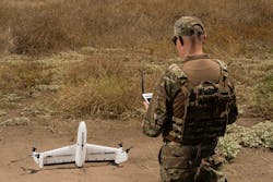
UPS has announced that starting in May, its subsidiary UPS Flight Forward and CVS will use drones to deliver prescription medicines from a CVS pharmacy to The Villages, Florida, which is the largest U.S. retirement community, home to more than 135,000 residents.
Utilizing Matternet’s M2 drone system, the service will operate under the FAA’s Part 107 rules, with authority to operate through the Coronavirus pandemic and explore ongoing needs as they arise after that period. The operation could expand to include deliveries from two more CVS pharmacies in the area.
During the first flights, which are expected to be less than one half mile, deliveries will be made to a location near the retirement community. To start, a ground vehicle will complete the delivery to the resident’s door.
“Our new drone delivery service will help CVS provide safe and efficient deliveries of medicines to this large retirement community, enabling residents to receive medications without leaving their homes,” says Scott Price, UPS chief strategy and transformation officer.
“UPS is committed to playing its part in fighting the spread of Coronavirus, and this is another way we can support our healthcare customers and individuals with innovative solutions.”
In 2019, UPS and CVS announced plans to jointly explore using drones to make deliveries. In Nov. 2019, they successfully completed their first drone deliveries of medical prescriptions from a CVS pharmacy in Cary, North Carolina.
“Now more than ever, it’s important that our customers have access to their prescriptions,” says Jon Roberts, executive vice president and chief operating officer of CVS Health.
“In addition to our in-store pickup, free delivery services and drive through pickup, this drone delivery service provides an innovative method to reach some of our customers.”
AeroVironment unveils fully automated reconnaissance UAS
AeroVironment has unveiled Quantix Recon, the company's new lightweight, rapidly deployable, fully-automated reconnaissance UAS that provides ground forces with on-demand actionable intelligence by delivering high resolution, georeferenced terrain, vegetation and infrastructure imagery.
Quantix Recon’s design combines the vertical takeoff and landing (VTOL) advantages of a multirotor drone with the range, speed and efficiency of a fixed-wing UAS, resulting in what AeroVironment describes as a unique hybrid VTOL design.
Built to operate fully autonomously during flights, Quantix Recon can survey up to 1.6 square kilometers (0.6 square miles), or 20 linear kilometers (12.4 miles) per 45-minute single battery flight.
“AeroVironment’s Quantix Recon is a low-cost reconnaissance solution that can be in the air within minutes, capturing high-resolution georeferenced imagery of hard to access areas or dynamically changing environments.” says Rick Pedigo, vice president of sales and business development for AeroVironment.
“Because it does not rely on radio signals during flight, Quantix Recon offers greater stealth for concealed operations and is unaffected by radio frequency jammers, providing greater protection for frontline troops while reducing cognitive load.”
Equipped with multiple automated reconnaissance mode options, users can choose between line (route), area and waypoint targeted data capture. Collected aerial imagery data can be further analyzed thanks to that data being compatible with a wide range of available geographic information system (GIS) analytical tools.
Fully-automated and hands-free with five optional flight altitudes ranging from 150 feet to 800 feet, Quantix Recon’s simple, automated operation allows users to easily vary the coverage area and image resolution to suit their aerial reconnaissance needs.
Quantix Recon is equipped with dual 18-megapixel cameras that can capture both high resolution true color and multispectral georeferenced imagery. Thanks to Quantix Recon’s powerful, on-board processing, users can immediately view the high-resolution geospatial imagery on the included operating tablet as soon as the aircraft lands, without the need for other devices, internet or software.
Through the operating tablet’s Quick-Look HD app feature, users can pinch and zoom navigation down to centimeter-level ground sampling distance, which allows them to pinpoint and react to critical issues with precision and speed.

OSU to use funding to improve safety for UAS flying in Advanced Air Mobility operations
A team of researchers from Oklahoma State University (OSU) has been recognized with the University Leadership Initiative (ULI) Award from NASA, and will receive $5.2 million in funding over the next four years to address some of NASA’s strategic research initiatives.
Featuring faculty members and students from the College of Engineering, Architecture and Technology, the OSU team will seek to improve real-time weather forecasting of low-level winds and turbulence in both rural and urban environments, with the ultimate goal of improving safety for UAS flying in Advanced Air Mobility (AAM) operations.
Jamey Jacob, the director of OSU’s Unmanned Systems Research Institute, is the project’s principal investigator. The other OSU investigators include professors Brian Elbing, Imraan Faruque and Nicoletta Fala.
OSU’s team is also made up of members from several universities and entities including Oklahoma State University, the University of Oklahoma and Choctaw Nation of Oklahoma.
“Selection to the NASA University Leadership Program confirms OSU’s expertise and preeminence in unmanned systems, particularly in the area of unmanned aircraft for weather and meteorological applications,” Jacob says.
The lead institution for this initiative, OSU is one of five university teams to receive the ULI award and a share of $32.8 million in funding over the next four years. The other teams awarded were from Stanford University, the University of Delaware, North Carolina A&T State University and the University of South Carolina.
“Each of these teams is working on important problems that definitely will help break down barriers in ways that will benefit the U.S. aviation industry,” says John Cavolowsky, director of NASA’s Transformative Aeronautics Concepts Program in Washington, D.C.
The goal of the University Leadership Initiative is to unite NASA’s Aeronautics Research Mission Directorate (ARMD) and prominent American research universities to produce “new, innovative ideas.”
Compiled by Brian Sprowl, Associate Editor, AUVSI
Share your vision-related news by contacting Dennis Scimeca, Associate Editor, Vision Systems Design
SUBSCRIBE TO OUR NEWSLETTERS