Drones assist personal injury law firm in recreating vehicle accident scenes
In this week’s roundup from the Association for Unmanned Vehicle Systems International, which highlights some of the latest news and headlines in unmanned vehicles and robotics, drones recreate vehicle accident scenes for a personal injury law firm, remote operation of canine-inspired robots, and new navigational capabilities for unmanned surface vehicles.
Witherite Law Group to use drones during accident investigations
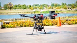
Dallas-based personal injury law firm Witherite Law Group and commercial drone services firm Midwest UAS Technologies have partnered to use drones to improve how an insurance company and jury visualize a car or truck wreck and the accident scene.
“When we talk about why expertise matters in car and truck wrecks, this is what we mean,” says Witherite Law Group Founding Partner and Commercial Truck Accident Lawyer, Amy Witherite.
“Drones will extend, enhance and grow our accident investigation expertise. This expertise will be a major advantage for our clients in our battle to ensure they receive the insurance settlements they deserve.”
The drones will provide up-to-date maps, video and images that will allow Witherite Law Group’s attorneys to recreate a highly accurate accident scene. The technology will also allow the firm to reflect near real-time conditions at the time of the accident.
“This partnership will raise the bar in evidence gathering and accident reconstruction in Dallas and Fort Worth. The technology will enhance the firm’s ability to visualize and interact with a scene to the benefit of their clients,” says Jackie Reiser, owner, Midwest UAS Technologies.
“And the firm will benefit by completing inspections and data collection in a fraction of the time of manual methods. Easy access to difficult-to-reach areas will also increase the safety of their employees.”
Rocos, Boston Dynamics partner to enhance existing capabilities of Spot robot
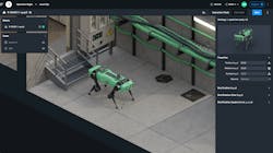
Robot operations software platform provider Rocos has partnered with Boston Dynamics to enhance the existing capabilities of Boston Dynamics’ Spot robot. Through the partnership, remote mission design and execution, as well as a teleoperation functionality, will be integrated into Spot.
Built to go where other robots cannot, Spot is a mobile, durable, and customizable robot. Equipped with the Rocos platform, the robot can now be managed from a remote location. Missions can be designed and edited on the fly, and remote teams can access sensor data collected during the mission. The robot can also be manually teleoperated to investigate issues, capture new data, or be redirected as required.
“The age of autonomous robots is upon us. We’re working with organizations like Boston Dynamics to help accelerate the adoption of robotics. By connecting robots to the cloud, we can help them combine a cloud software layer with robotics to achieve physical automation at scale,” explains Rocos CEO David Inggs.
“Our customers are augmenting their human workforces to automate physical processes that are often dull, dirty, or dangerous. I’m excited to be working with the world-class team at Boston Dynamics.”
Capable of navigating rugged environments, Spot collects data in real-time and feeds that data back into existing business systems no matter where they are located.
A variety of industries can benefit from Spot's new capabilities. In the energy sector, real-time anomaly detection is provided, as well as access to historic digital records for comparison. In agriculture, farmers can access information such as more accurate and up-to-date yield estimates, which provides access to a new category of automation, and a safer, more efficient business, the companies say.
Organizations that utilize this joint technology will be able to plan and schedule missions, remotely operate their robots in the exploration of uncharted territory, capture 3D visualizations and other sensor data in their environment, navigate risky or dangerous terrain, and proactively intervene in required situations—all of which is possible in either offline or online modes.
During early testing, the Boston Dynamics team based in the United States navigated previously uncharted terrain in New Zealand, and using Rocos’ web UI, the team was able to remotely access Spot.
“Robotics companies are producing very capable machines for achieving specific tasks. The missing link is a cloud-based platform to connect, monitor and automate the activities of a fleet,” Inggs says.
“With Boston Dynamics and Rocos, organizations can now design, schedule and manage inspection missions remotely.”
Sonardyne demonstrates tech that will help autonomous vehicle ops in challenging environments
Under a project funded by the UK’s national Defence and Security Accelerator (DASA), Sonardyne International Ltd. demonstrated technologies that it says will help autonomous vehicle operations in challenging environments.
Sonardyne worked with a 12-meter-long SEA-KIT X class USV, and tested and validated sensors already used by UUVs for use on USVs in support of missions in coastal waters.
The SEA-KIT X was equipped with Sonardyne’s SPRINT-Nav hybrid inertial navigation instrument, which was tested against local real-time kinematic (RTK) GPS positioning as part of the DASA program to fast-track autonomous vehicle capability in challenging or harsh conditions.
Sonardyne notes that in areas where GPS or GNSS receivers may not have a clear line of sight with the sky such as in ports and harbors around tall structures or close to cliffs or inside fjords, satellite-based timing signals needed for navigation and positioning can be lost. Deliberate signal jamming or degrading of performance, known as spoofing, can also cause a loss of satellite-based timing signals.
“Most USVs rely on uninterrupted GPS or GNSS signal updates to inform their situational awareness and plot a course safely. When there’s no signal, or what’s called spoofing or jamming, USVs must consider alternativ navigation sensors and instruments or they need to be remotely piloted adding expense and risk to over-the-horizon operations,” explains Ioseba Tena, Global Business manager, Defence and Marine Robotics at Sonardyne.
“By integrating SPRINT-Nav onto a USV, such as SEA-KIT, we have shown we can overcome this challenge, providing a continuous and resilient navigation in denied environments capability that will be ideally suited to challenging operations such as mine-counter measures (MCM).”
Thus far, Sonardyne’s SPRINT-Nav has been proven as a reliable navigation instrument for UUVs, which operate in what is effectively a GPS or GNSS denied environment. The instrument will now also be used to provide a high integrity, continuously available navigation technology for a USV such as the SEA-KIT X, operating in littoral zones in water depths up to 150 meters.
Capable of carrying up to 2.5 tons of payload, SEA-KIT is a 10,000 nautical mile-range vessel that can deploy and recover UUVs and ROVs, making the vessel ideal for supporting naval missions including intelligence gathering, hydrographic survey and as a communications gateway.
Compiled by Brian Sprowl, Associate Editor, AUVSI
Share your vision-related news by contacting Dennis Scimeca, Associate Editor, Vision Systems Design
SUBSCRIBE TO OUR NEWSLETTERS