New safety device for autonomous vehicles assesses road conditions
In this week’s roundup from the Association for Unmanned Vehicle Systems International, which highlights some of the latest news and headlines in unmanned vehicles and robotics, TomTom launches a new product that protects drivers from unsafe conditions for autonomous driving, drone deliveries in Brazil, and phase two of New York State’s unmanned aircraft traffic management pilot program.
TomTom launches new product to ensure safe automated driving operations
TomTom (TOM2) has launched a new product for automated vehicles called TomTom RoadCheck that allows carmakers to decide where it is safe for drivers to activate their vehicles’ automated driving functions.
TOM2 notes in certain instances such as during periods of adverse weather, in tunnels, and in changing environments, automated driving operations might not be safe. In these instances, RoadCheck enables carmakers to define the operational design domain (ODD) of their vehicles’ automated driving functions using TomTom’s high definition (HD) map data, which gives carmakers the ability to manage where these functions can be used safely.
“By enabling carmakers to control where automated driving functions can be activated, TomTom is addressing a critical industry challenge that has been highlighted by our partners and customers,” explains Willem Strijbosch, head of Autonomous Driving at TomTom.
“TomTom RoadCheck – an industry first technology – will make safe autonomous driving a reality sooner.”
TomTom RoadCheck is the latest edition to TomTom’s vehicle automation portfolio, which also includes the TomTom HD Map, the TomTom ADAS Map, a hazard service, TomTom AutoStream and TomTom Vehicle Horizon.
TomTom says that RoadCheck will be deployed in a production model by a leading global carmaker in 2021, starting in the United States.
Speedbird Aero receives regulatory approval to operate two experimental drone delivery routes in Brazil
Speedbird Aero, a Latin American drone delivery company, has become the first company in Latin America to win regulatory approval for a drone delivery operation, as the company has received regulatory approval from Brazil's National Civil Aviation Agency, also known as ANAC, to operate two experimental drone delivery routes in Brazil.
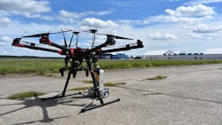
Speedbird Aero operates a proprietary delivery drone with an integrated ParaZero parachute recovery system. The company has partnered with a Latin American food delivery company called iFood to offer an on-demand food delivery service that combines drone delivery with other forms of last-mile transportation such as motorcycles, bicycles, scooters, and e-bikes. The approved drone delivery routes will link two iFood Hubs with a food court and condominium complex, and will greatly reduce ground transportation time typically required for deliveries.
For the first delivery route, drones will pick up orders from the rooftop of a large shopping complex in São Paulo and transport them to a nearby iFood pickup hub. Couriers waiting at the hub will shuttle orders to their final destinations. Each delivery route will take the drones approximately two minutes to fly.
For the second delivery route, drones will fly beyond visual line of sight (BVLOS) to a secondary iFood pickup hub approximately 1.5 kilometers away. According to Speedbird Aero, this phase, which is expected to begin by December of this year, will enable a broader distribution footprint.
“Our goal is to continue the development of unmanned aerial logistics in Brazil and Latin America with safety in mind,” says Samuel Salomão, Speedbird Aero's co-founder.
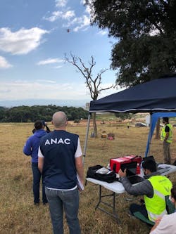
Throughout the certification process, which took more than one year to complete, ANAC regulators assessed the safety management and risk mitigation planning aspects of Speedbird Aero's operations, which included a ParaZero autonomous parachute system for each delivery drone in Speedbird Aero's fleet. As part of the certification process, Speedbird Aero was required to perform six parachute deployments, including a final live parachute deployment in front of a team of ANAC officials on July 9.
“All of these steps are part of a process that will culminate into a commercial product,” says Manoel Coelho, co-founder of Speedbird Aero.
New York UAS Test Site selected to participate in Phase 2 of UPP program
The FAA has selected the New York UAS Test Site at Griffiss International Airport in Rome, New York and the Virginia Tech Mid-Atlantic Aviation Partnership in Blacksburg, Virginia to participate in phase two of the unmanned aircraft traffic management pilot program (UPP).
During UPP Phase 2, capabilities and services that support high-density UAS operations will be showcased, including remote identification services and public safety operations. Data collected from UPP Phase 2 tests will help inform a cross-agency unmanned traffic management (UTM) system implementation plan.
“We couldn’t be happier that the FAA has selected Oneida County’s New York UAS Test Site at Griffiss to develop the next phase of UAS traffic management,” says Oneida County Executive Anthony J. Picente Jr.
“That our site has been chosen from what is already a small, elite group that has been granted test site status, is a testament to the high quality of work and collaboration of our partners in Rome. It’s an honor to be on the forefront of the next evolution of this transformative technology.”
UPP Phase 1 was completed in Aug. 2019, in collaboration with NASA, FAA UAS test sites and their industry partners. Several capabilities were tested during Phase 1, including the exchange of flight data among UAS operators and generating an emergency “no-fly zone” for general unmanned aircraft, clearing the skies for emergency response drones.
Over the past five years, more than 3,000 advanced UAS test flights, including UTM tests, have been conducted at the NY UAS Test Site. New York’s 50-mile drone corridor, which starts at the test site in Rome and stretches across the state to Syracuse, has the necessary infrastructure and technologies in place to complete the advanced drone operations and UTM standardization work outlined in UPP Phase 2.
To complete the work outlined in UPP Phase 2, Oneida County and the New York UAS Test Site have partnered with multiple local, national and international organizations, including AiRXOS, Albany County Sheriff’s Office, Johns Hopkins University – Applied Physics Lab (on behalf of the FAA TCAS Program Office), Northeast UAS Airspace Integration Research Alliance Inc. (NUAIR), and the Syracuse Fire Department, to name a few.
Virtual collaboration on UPP Phase 2 began in mid-April of this year. Live flights and component testing will take place at the Test Site starting this month.
“The New York UAS Test Site being selected by the FAA to take part in this next phase speaks to the amount of meaningful testing and research we’ve been doing here in Central New York to advance the industry,” says Tony Basile, chief operations officer of NUAIR.
“The collaborative work we will achieve with our industry-leading partners will help shape the commercial drone industry on a national, if not international level.”
Compiled by Brian Sprowl, Associate Editor, AUVSI
Share your vision-related news by contacting Dennis Scimeca, Associate Editor, Vision Systems Design
SUBSCRIBE TO OUR NEWSLETTERS