Commercial scanner launched by NASA contractor
Engineers atNeptec Technologies (Kanata, Ontario, Canada) have developed a scanner and an associated software suite that enables users to collect just the right amount of 3-D data that is needed in their surveillance or autonomous navigation applications.
The company's OPAL 2.0 laser scanners incorporate LiDAR technology which was originally developed for helicopters landing in brownout conditions in the desert. They have been packaged for conditions typically found in the mining, oil and gas, and construction industries.
Over the course of many projects for NASA and other clients in the space market, Neptec developed a collection of 3-D data algorithms and real-time software for automatic change detection, 3-D data alignment and object recognition and tracking.
That software, which it calls 3DRi (3D Real-time intelligence), has now been incorporated into a software development toolkit that runs under Windows 7 (32 or 64 bit) and Ubuntu Linux 11.10 (32 or 64 bit).
When used in conjunction with the scanner, the 3DRi software suite can detect changes in a scene in real-time as well as perform object recognition and tracking. That makes it possible to collect sparse 3-D data in real-time from the laser scanners, look for interesting changes, and then dynamically increase the data density that is acquired to inspect an item of interest.
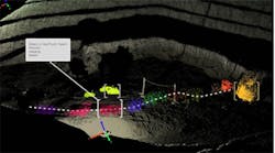
The image above shows how the system has been deployed to tracking a truck in the loading area of a open pit mine.
Neptec Technologies was founded in 2011 to commercialize space-technologies developed by Neptec Design Group, an award-winning space flight technology company and NASA prime contractor.
Related items from Vision Systems Design that you might also find of interest.
1.Lidar system scans mineshafts
Canada-based Sight Power, is working with Shaft Sinkers Holdings and Parsec to develop a Mobile Shaft Scanning System (MS3) that will fully automate the inspection of mineshafts.
2.Portable mapping system in a backpack
Engineers from the Applied Physics Laboratory at Johns Hopkins University (APL, Laurel, MD, USA) have developed a portable mapping system carried in a backpack that can automatically create annotated physical maps of locations such as underground areas and ships.
3.Imaging system to help diagnose psoriasis
A team from the Rochester Institute of Technology (Rochester, NY, USA) is seeking to improve the diagnosis and assessment of psoriasis through the creation of a multimodal, image-based analysis system.
-- Dave Wilson, Senior Editor,Vision Systems Design
