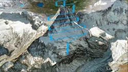
UAVs create 3D model of the Matterhorn
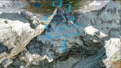
Sensefly, the creator of the lightweight, vision-enabled eBee unmanned aerial vehicle (UAV), or drone, has teamed up with Drone Adventures-a non-profit company which promotes the potential use of drones in drones in civilian applications-to autonomously map the entire Matterhorn Mountain. eBee drones are equipped with a rear-mounted propeller and feature a 16 MPixel camera which is electronically integrated and controlled. The UAVs also come with Postflight Terra 3D-EB mapping software that runs off a desktop computer or laptop and processes aerial imagery into 2D maps and 3D models. >>>Read more.
About the Author

James Carroll
Former VSD Editor James Carroll joined the team 2013. Carroll covered machine vision and imaging from numerous angles, including application stories, industry news, market updates, and new products. In addition to writing and editing articles, Carroll managed the Innovators Awards program and webcasts.